Author Topic: Geography and Naval Deployments  (Read 1317 times)

Pendrake

  • Lieutenant J.G.
  • *
  • Posts: 52
  • Number of Times Thanked: 1
    • View Profile
    • Pendrakes Blogspot
Geography and Naval Deployments
« on: April 08, 2013, 09:57:44 pm »
I am watching the news (almost filed this under 'What Are You Watching') and it is all about Korea.

I have a couple of 'maps'* to show off which should be of interest to anybody keeping up with current naval events.

First up Korea - The Center of the World:

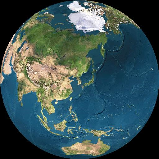
This is how the globe looks if the Korean peninsula is plotted at the very center. Very useful for understanding what is closest to Korea and what is under the flight path to some particular point.

Second map: A Great Circle: Korea to CONUS** (As the Tern*** Flies).

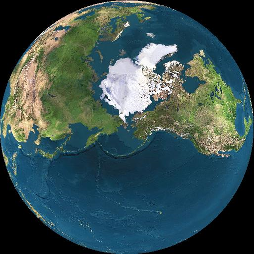
On this map a straight horizontal line across the middle would connect the Korean peninsula to the US along the shortest possible path. That path makes it clear why this:

is deployed somewhere in the Bering Sea, why Fort Greely, Alaska is where our interceptor missiles are, and why Aegis Destroyers are deployed to the Sea of Japan. All of those are waypoints on the potential flight path to the US.


*The maps came from:http://www.fourmilab.ch/cgi-bin/Earth (a nifty online globe map resource. Just plug in the correct options and generate whatever view of Earth you might want.)
** Continental United States (for anyone that doesn't know that one.)
***Crows lack the range...
1:1200 - One inch equals One Hundred feet...

Ruckdog

  • Administrator
  • Admiral
  • *****
  • Posts: 3050
  • Number of Times Thanked: 189
  • Dive! Dive!
    • View Profile
    • Man Battlestations!
Re: Geography and Naval Deployments
« Reply #1 on: April 09, 2013, 10:42:38 am »
Very cool pictures! They really do help put our current deployments in perspetive. How often we forget that the world is not actually flat, despite what our maps (and game boards/tables!) lead us to believe....

Fracas

  • Lieutenant Commander
  • ***
  • Posts: 335
  • Number of Times Thanked: 33
    • View Profile
    • Warmancer
Re: Geography and Naval Deployments
« Reply #2 on: April 09, 2013, 11:36:49 am »
Good use or perspective
Firestorm: Aquan, Directorate, Retholza, Hawker (FsA)/ Terran (FsPf), RSN (FsA)/ Dindrenzi (FsPf)
DW: EotBS, FSA, PLC.
Warmaster: Kislev, Khemri, Dwarves,
BFG: Pacification Fleet (IN), Tau Expeditionary (SG), Battlefleet (Chaos), Kher-Ys Corsairs, Crusade Fleet (IN),
LotR: Khand, Gondor, Mordor

MajorMcNicol

  • Lieutenant
  • **
  • Posts: 205
  • Number of Times Thanked: 2
  • Regret #9
    • View Profile
    • Andy G. and Ian C.
Re: Geography and Naval Deployments
« Reply #3 on: May 18, 2013, 10:27:36 am »
This was cool!  Thanks for posting.  Made me think about how commercial flights often flight North when going East or West in order to reduce the total distance. 

Old topic, I know, but still a cool one to look at!
http://andygomez.wordpress.com/
UPDATED Canons de Zibeline DW Merc Company rules: https://drive.google.com/file/d/0B_gsuBDmdvmLNFduUHRWMEtVbTA/view?usp=sharing

Check out my brother's novel on Amazon: Out From the Chasm by Keenan Cross